HiSET Social Studies Study Guide: Geography
Geography questions will assess your knowledge and understanding of:
- Basic terminology
- Geographic concepts
- Maps and other visual stimuli
Geography Vocabulary
If you’ve ever read a map, you’re likely familiar with many of these need-to-know geography vocabulary terms.
Almanac
A calendar that includes information on tides, crop planting dates, sunrise/sunset times, and moon phases.
Atlas
A book containing many maps and charts.
Climate
An area’s weather patterns over a long period of time (e.g. years).
Compass Rose
A figure that indicates the cardinal directions (i.e. north, south, east, and west) on a map.
Contour Lines
A feature of topographic maps that represents elevation changes on a two-dimensional surface.
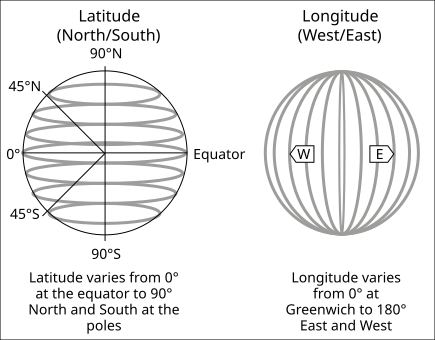
Equator
An imaginary line running around the Earth at an equal distance from both poles. It separates the Earth into the Northern and Southern Hemispheres.
Prime Meridian
An imaginary line that indicates 0° longitude. 180° east or west from it forms the International Date Line. It separates the Earth into the Eastern and Western Hemispheres.
Time Zones
Set areas that observe standardized times, allowing people worldwide to coordinate commerce and other activities. Time zones represented on a globe would look much like slices of an orange.
Longitude and Latitude
Geographers use longitude and latitude to express a place’s absolute location on Earth’s surface.
Source: See page for author, Public domain, via Wikimedia Commons
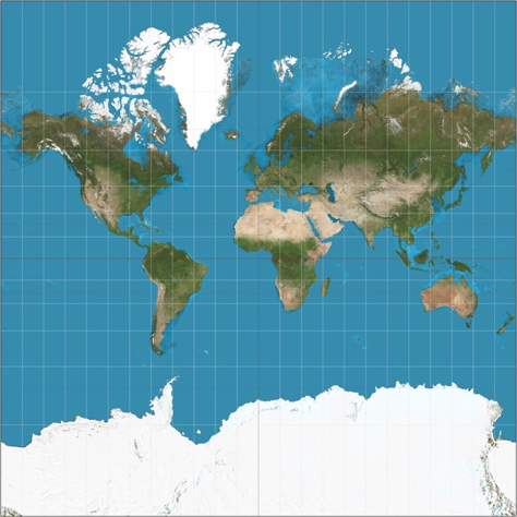
Map Projections
Because the Earth is a three-dimensional sphere, it is impossible to represent its features 100% accurately on a two-dimensional map. That’s why cartographers (i.e. map makers) must choose a two-dimensional projection with some level of distortion. One of the most well-known is the Mercator Projection:
Source: Strebe, CC BY-SA 3.0, via Wikimedia Commons
In the Mercator Projection, longitude and latitude lines remain perpendicular. However, distortion makes the areas in low and high latitudes appear much bigger than in real life.
Types of Maps
Projection isn’t a cartographer’s only decision when creating a map. They must also pick what kind of information their map will feature. The table below defines a few different map types.
| Type of map | Main features |
| Topographic map | Topographic maps use contour lines to show elevation changes. |
| Resource map | Resource maps show the location and amounts of natural resources, such as coal, oil, or gold. |
| Political map | Political maps show local, state, and national boundaries. |
| Thematic map | Thematic maps provide information on a specific theme, such as highlighting the percentage of literate people in each country. |